Book Image

QGIS Quick Start Guide

By : Andrew Cutts
Book Image

QGIS Quick Start Guide

By: Andrew Cutts

Overview of this book

QGIS is a user friendly, open source geographic information system (GIS). The popularity of open source GIS and QGIS, in particular, has been growing rapidly over the last few years. This book is designed to help beginners learn about all the tools required to use QGIS 3.4. This book will provide you with clear, step-by-step instructions to help you apply your GIS knowledge to QGIS. You begin with an overview of QGIS 3.4 and its installation. You will learn how to load existing spatial data and create vector data from scratch. You will then be creating styles and labels for maps. The final two chapters demonstrate the Processing toolbox and include a brief investigation on how to extend QGIS. Throughout this book, we will be using the GeoPackage format, and we will also discuss how QGIS can support many different types of data. Finally, you will learn where to get help and how to become engaged with the GIS community.
Table of Contents (9 chapters)

Labeling

Open the QGIS project we built in Chapter 4, Styling Data. We will be using it to build a map. Turn on the Label Toolbar by selecting View | Toolbars and select Label Toolbar. Label Toolbar is shown as follows:
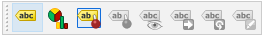
Labeling toolbar

There are eight buttons on this toolbar; in order, these are the following:

  • Clicking on Layer Labeling Options will open the Layer Styling Panel and the label tab by default
  • Layer Diagram Options
  • Highlight Pinned Labels and Diagrams
  • Pin/Unpin Labels And Diagrams
  • Show/Hide Labels And Diagrams
  • Move Label and Diagram
  • Rotate Label
  • Change Label, used for label editing

Make sure that the Airports layer is selected in the Layers panel. Click on the layer labeling button on Label Toolbar. This will open the Layer Styling Panel; we used this in the previous chapter to style our layers. Choose Single labels and the label with NAME to label all Airports...