
Raster terrain analysis can be used to calculate the slope, aspect, hillshade, ruggedness index, and relief from elevation rasters, as shown in the following screenshot. These tools are available through the Raster | Terrain analysis plugin, which comes with QGIS by default, but we have to enable it in the Plugin Manager.
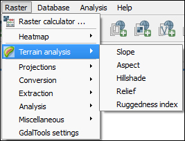
The Terrain analysis includes the following tools:
Slope: This tool calculates the slope angle for each cell in degrees (based on the first order derivative estimation)
Aspect: This tool calculates the exposition (in degrees counter-clockwise, starting with 0 for north)
Hillshade: This tool creates a basic hillshade raster with lighted areas and shadows
Relief: This tool creates a shaded relief map with varying colors for different elevation ranges
Ruggedness Index: This tool calculates the ruggedness index for each cell by summarizing the elevation changes within a 3 x 3 cell grid
Of course, to use any of these terrain analysis tools, we...