

Sharing GIS data was a difficult proposition in the past, as if you didn't have your own infrastructure, there wasn't a central place where people could share GIS data. This meant that most data lived as a hyperlink to a .zip file of a shapefile or a .kmz file, being hidden deep within a website not devoted to GIS. The age of the file was sometimes unknown, because there was no metadata or nothing on the website that told you whether the files were being updated or when they were created. With the introduction of ArcGIS Online, people and organizations have a central place where they can share GIS data and give the burden of hosting and serving the data to Esri. There are also many websites that use open-source solutions to serve out data in the form of a web mapping service (WMS) or a web feature service (WFS).
Note
Just like everything on the internet, don't automatically assume data is correct. There's a lot of bad data out there. Unsure about a dataset? Try contacting the person or organization who created it.
With GIS being more accessible, and with more demand for GIS data, it truly is a good time for the GIS professional. However, you must be wary of datasets—How they were created? If they are maintained? And/or whether the data is complete or not? Inspect every dataset to find:
- Metadata, if available
- Who created the data?
- Do field names make sense, or do you need a key/lookup table for them?
- What scale was the data drawn at?
- What is the accuracy, spatially and mathematically?
- What is the licensing of the data?
These are some of the questions you should ask yourself when searching out data online.
Not all of your data needs are going to be useful as static files on your file server or local machine. It may be that the data you need is too large or changes so often you'd rather not have to go out every day/week/month to download the newest version. There is a lot of dynamic data being served out in the web, so when you access it, you are always getting the most up-to-date data and only getting the data you need. Not having to store the data locally and being able to just pull the data from a server can be very advantageous. For example, if you want to create a map showing the current weather, it may not be necessary to keep the weather data for a historical archive. The purpose of the map is to show current weather, so you pull live data from a governmental body or commercial provider to overlay your map. That way, if it's a web map, you don't have to worry about keeping things up to date, and if it's a layer in a static map, every time you export or print it will show the updated data. This works well when GIS is needed in an operations center where a large map is printed every so often.
Some of the biggest GIS data creators are governments. Many governments produce a whole lot of data, but most have one flaw. They don't advertise it well. Thankfully, search engine crawlers do a great job of digging deep into complex government websites and allowing us to search for the keywords we are looking for. Adding keywords like shapefile, geodatabase, GIS, REST, WMS, and WFS to what you are trying to find can make searching quicker. In the United States, you can use https://data.gov to search against a large amount of federal, state, county, and local data. In Europe, you have https://data.europa.eu or https://www.europeandataportal.eu.
Esri has a data repository called the Living Atlas, which contains curated data from Esri that you can use in your maps. The majority of these datasets are available to the public, but there are a few datasets in Living Atlas that are either subscriber content or premium content. The last two types of Living Atlas datasets require you to have an ArcGIS organizational account and/or credits available. Warning! Be careful with credit consumption; it can add up real quick and can drain your organization's credits. You can access the Living Atlas data two ways:
- Through ArcGIS Pro
- At https://arcgis.com
In ArcGIS Pro, you can access the data through the Catalog pane under Portal by clicking on the icon with the book on top of a cloud, shown as the following:
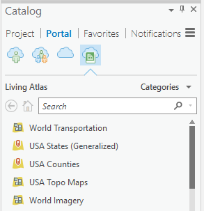
Figure 1.1: Living Atlas Data in ArcGIS Pro
You can also search for Living Atlas on ArcGIS Online to find datasets. A great feature of ArcGIS Online is being able to find a layer there and open it within ArcGIS Pro automatically. We will go into more depth on this in Chapter 9, Get Started with ArcGIS Online. ArcGIS Online also has data from people and organizations around the world. Because they chose to leverage ArcGIS Online to host their data, you can be sure that it will come into your map in ArcGIS Pro with little to no configuration. ArcGIS Pro was designed around consuming data from GIS servers just as much as it was designed for local data.