

OpenLayers comes with lots of controls to interact with the map: pan, zoom, show overview map, edit features, and so on.
In the same way as layers, the OpenLayers.Map class has methods to manage the controls attached to the map.
Create a new HTML file and add the OpenLayers dependencies.
Now, add the required code to create the buttons and
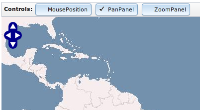
divelement to hold the map instance:<div class="sample_menu" dojoType="dijit.MenuBar"> <span class="title">Controls: </span> <div dojoType="dijit.form.ToggleButton" iconClass="dijitCheckBoxIcon" onChange="updateMousePosition">MousePosition</div> <div dojoType="dijit.form.ToggleButton" iconClass="dijitCheckBoxIcon" onChange="updatePanPanel">PanPanel</div> <div dojoType="dijit.form.ToggleButton" iconClass="dijitCheckBoxIcon" onChange="updateZoomPanel">ZoomPanel</div> </div> <!-- Map DOM element --> <div id="ch1_managing_controls" style="width: 100%; height: 500px;"></div>Within the
scriptelement section, create the map instance:var map = new OpenLayers.Map("ch1_managing_controls", { controls: [ new OpenLayers.Control.Navigation() ] });Add some layers to the map and center the view:
var wms = new OpenLayers.Layer.WMS("OpenLayers WMS Basic", "http://vmap0.tiles.osgeo.org/wms/vmap0", { layers: 'basic' }, { wrapDateLine: false }); map.addLayer(wms); // Center the view map.setCenter(OpenLayers.LonLat.fromString("0,0"),3);Finally, add the actions code associated to the buttons:
function updateMousePosition(checked) { if(checked) { map.addControl(new OpenLayers.Control.MousePosition()); } else { var controls = map.getControlsByClass("OpenLayers.Control.MousePosition"); console.log(controls); map.removeControl(controls[0]); } } function updatePanPanel(checked) { if(checked) { map.addControl(new OpenLayers.Control.PanPanel()); } else { var controls = map.getControlsByClass("OpenLayers.Control.PanPanel"); map.removeControl(controls[0]); } } function updateZoomPanel(checked) { if(checked) { // Place Zoom control at specified pixel map.addControl(new OpenLayers.Control.ZoomPanel(), new OpenLayers.Pixel(50,10)); } else { var controls = map.getControlsByClass("OpenLayers.Control.ZoomPanel"); map.removeControl(controls[0]); } }
Every button action function checks if the toggle button is checked or unchecked and depending on the value we add or remove the control to the map:
if(checked) {
// Place Zoom control at specified pixel
map.addControl(new OpenLayers.Control.ZoomPanel(), new OpenLayers.Pixel(50,10));
} else {
var controls = map.getControlsByClass("OpenLayers.Control.ZoomPanel");
map.removeControl(controls[0]);
}Adding a control is fairly simple through the map.addControl() method, which, given a control instance—and, optionally a OpenLayers.Pixel instance—adds the control to the map at the specified position.
Note
Usually, a control position is controlled by modifying the top and left values in the CSS class used by the control. If you use a OpenLayers.Pixel value to position the control, then that value will overwrite the CSS ones.
To remove a control we need to have a reference to the instance that has to be removed. The method map.getControlsByClass() returns an array of controls of the specified class and helps us to get a reference to the desired control. Next, we can remove it with map.removeControl().
Note, in this recipe we have centered the map's view passing a OpenLayers.LonLat instance created in a different way. Instead of using the new operator, we have used the method OpenLayers.LonLat.fromString, which created a new instance from a string:
map.setCenter(OpenLayers.LonLat.fromString("0,0"),3);In addition, the map instance created in this recipe has initialized with only one control, OpenLayers.Control.Navigation(), which allows us to navigate the map using the mouse:
var map = new OpenLayers.Map("ch1_managing_controls", {
    controls: [
    new OpenLayers.Control.Navigation()
    ]
});Note
Passing an empty array to the
controls property creates a map instance without any control associated with it. In addition, without specifying the controls property, OpenLayers creates a set of default controls for the map, which includes the OpenLayers.Control.Navigation and OpenLayers.Control.PanZoom controls.