-
Book Overview & Buying

-
Table Of Contents

Mastering QGIS
By :

Mastering QGIS
By:
Overview of this book
 Free Chapter
 Sign In
Start Free Trial

 Free Chapter
To begin a model, you will need to define the inputs. The graphical modeler will accept the following:
Boolean
Extent
File
Number
Raster layer
String
Table
Table field
Vector layer
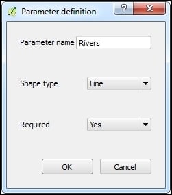
To add an input, either double-click on the appropriate category from the Inputs tab or drag the input onto the modeler canvas. The Parameter definition dialog will open. Give the parameter a name and fill in any other details, which change depending on the input that is chosen. When an input parameter is defined and added to the model, it is essentially a conceptual parameter. It will not actually be connected to a GIS data layer until you are ready to run the model.
For this example, we will add a vector layer. We will specify the geometry of the vector data and classify it as a required parameter:

Once you click on OK, the input object is added to the modeler canvas. All the objects in the modeler canvas can be selected with a mouse click and dragged to reposition. Clicking on the pencil icon of an input...

Change the font size
Change margin width
Change background colour