Book Image

Learning QGIS - Third Edition

By : Anita Graser
Book Image

Learning QGIS - Third Edition

By: Anita Graser

Overview of this book

QGIS is a user-friendly open source geographic information system (GIS) that runs on Linux, Unix, Mac OS X, and Windows. The popularity of open source geographic information systems and QGIS in particular has been growing rapidly over the last few years. Learning QGIS Third Edition is a practical, hands-on guide updated for QGIS 2.14 that provides you with clear, step-by-step exercises to help you apply your GIS knowledge to QGIS. Through clear, practical exercises, this book will introduce you to working with QGIS quickly and painlessly. This book takes you from installing and configuring QGIS to handling spatial data to creating great maps. You will learn how to load and visualize existing spatial data and create data from scratch. You will get to know important plugins, perform common geoprocessing and spatial analysis tasks and automate them with Processing. We will cover how to achieve great cartographic output and print maps. Finally, you will learn how to extend QGIS using Python and even create your own plugin.
Table of Contents (13 chapters)
Learning QGIS Third Edition
Credits
About the Author
About the Reviewer
www.PacktPub.com
Preface
Index

Dealing with project files


QGIS project files are human-readable XML files with the filename ending with .qgs. You can open them in any text editor (such as Notepad++ on Windows or gedit on Ubuntu) and read or even change the file contents.

When you save a project file, you will notice that QGIS creates a second file with the same name and a .qgs~ ending, as shown in the next screenshot. This is a simple backup copy of the project file with identical content. If your project file gets corrupted for any reason, you can simply copy the backup file, remove the ~ from the file ending, and continue working from there.

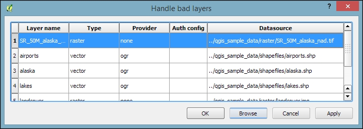
By default, QGIS stores the relative path to the datasets in the project file. If you move a project file (without its associated data files) to a different location, QGIS won't be able to locate the data files anymore and will therefore display the following Handle bad layers dialog:

Note

If you are working with data files that are stored on a network drive rather than locally...