Book Image

GeoServer Beginner's Guide - Second Edition

By : Stefano Iacovella
Book Image

GeoServer Beginner's Guide - Second Edition

By: Stefano Iacovella

Overview of this book

GeoServer is an opensource server written in Java that allows users to share, process, and edit geospatial data. This book will guide you through the new features and improvements of GeoServer and will help you get started with it. GeoServer Beginner's Guide gives you the impetus to build custom maps using your data without the need for costly commercial software licenses and restrictions. Even if you do not have prior GIS knowledge, you will be able to make interactive maps after reading this book. You will install GeoServer, access your data from a database, and apply style points, lines, polygons, and labels to impress site visitors with real-time maps. Then you follow a step-by-step guide that installs GeoServer in minutes. You will explore the web-based administrative interface to connect to backend data stores such as PostGIS, and Oracle. Going ahead, you can display your data on web-based interactive maps, use style lines, points, polygons, and embed images to visualize this data for your web visitors. You will walk away from this book with a working application ready for production. After reading GeoServer Beginner's Guide, you will be able to build beautiful custom maps on your website using your geospatial data.
Table of Contents (20 chapters)
Title Page
Credits
About the Author
About the Reviewer
www.PacktPub.com
Customer Feedback
Preface
Index

The About & Status section


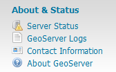
Starting from the top, this is the first section you find. It contains general information about the runtime variables and lets you check the logs to explore errors and warnings thrown by GeoServer when executing a client's request. Consider the following screenshot:

The Server Status link

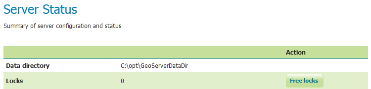
When you click on the Server Status link, it opens a form that gives you a nice overview of the main configuration parameters and information about the current state of GeoServer. A table view organizes the information. Other than being informative, this view lets you perform some maintenance operations.

From top to bottom, you will find several pieces of information:

  • The Data directory link (first row) shows you the location of the configuration files for GeoServer. If you managed to change the default location, here, you can check that GeoServer is using the new folder you created:
  • The Locks row shows you useful information for WFS-T editing. WFS-T stands for Transactional Web...