Book Image

OpenLayers 3.x Cookbook - Second Edition

By : Peter J. Langley, Antonio Santiago Perez
Book Image

OpenLayers 3.x Cookbook - Second Edition

By: Peter J. Langley, Antonio Santiago Perez

Overview of this book

OpenLayers 3 is one of the most important and complete open source JavaScript mapping libraries today. Throughout this book, you will go through recipes that expose various features of OpenLayers 3, allowing you to gain an insight into building complex GIS web applications. You will get to grips with the basics of creating a map with common functionality and quickly advance to more complicated solutions that address modern challenges. You will explore into maps, raster and vector layers, and styling in depth. This book also includes problem solving and how-to recipes for the most common and important tasks.
Table of Contents (14 chapters)
OpenLayers 3.x Cookbook Second Edition
Credits
About the Authors
About the Reviewer
www.PacktPub.com
Preface
Index

Exporting features as GeoJSON


In the earlier recipes, we saw how to read in data from different formats, such as GML and KML, but what about exporting data from a map? A user of your mapping application may want to get a copy of the vector layer data to use it somewhere else. Or perhaps, you're saving the state of a map and need to send the layer content to a server for persistent storage so that the same geometry can be retrieved later.

In this recipe, we will export the contents of a vector layer to the GeoJSON format. The source code can be found in ch03/ch03-export-geojson. Here's what we'll end up with:

How to do it…

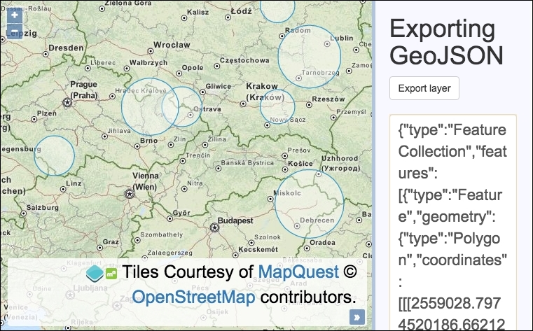
We are going to enable the use of an export button that will output the vector layer features as GeoJSON in a text box. Follow these steps to achieve this goal:

  1. Create the HTML file with OpenLayers dependencies. In particular, create the following:

    <div id="js-map"></div>
    <div>
      <h1>Exporting GeoJSON</h1>
      <form>
        <button type="submit...