Sign In Start Free Trial
Account

Add to playlist

Create a Playlist

Modal Close icon
You need to login to use this feature.
  • Book Overview & Buying Building Mapping Applications with QGIS
  • Table Of Contents Toc
Building Mapping Applications with QGIS

Building Mapping Applications with QGIS

By : Erik Westra
4.6 (9)
close
close
Building Mapping Applications with QGIS

Building Mapping Applications with QGIS

4.6 (9)
By: Erik Westra

Overview of this book

If you are an experienced Python developer who wants to create your own geospatial applications with minimum fuss, this is the book for you. While some familiarity with mapping applications would be an advantage, no prior knowledge of geospatial concepts is required. Even if you've never used QGIS before, this book will quickly get you up to speed.
Table of Contents (11 chapters)
close
close
Lock Free Chapter
1
1. Getting Started with QGIS
chevron up
10
Index

About QGIS

QGIS is a popular, free, and open source Geographic Information System (GIS), which runs on all major operating systems. People often use QGIS to view, edit, and analyze geospatial data. For our purposes, however, QGIS is more than just a GIS system; it is also a geospatial programming environment, which we can use to build our own geospatial applications using Python.

QGIS has a comprehensive website (http://qgis.org), which makes it easy to download, install, and use.

Before reading further, you should spend 15 minutes looking through the website and getting familiar with the application and the documentation available online. In particular, you should check out the Documentation page, where three important manuals are available: QGIS User guide/Manual, QGIS Training manual, and PyQGIS cookbook.

QGIS User guide/Manual provides in-depth user documentation, which you might find useful. QGIS Training manual is a detailed introduction to GIS systems and concepts based on QGIS; you might find it useful to work through this course if you aren't already familiar with geospatial data and techniques. Finally, PyQGIS cookbook will be an essential reference to use as you develop your own mapping applications built on top of QGIS.

Installing and running QGIS

If you haven't already installed QGIS, click on the Download Now button on the main QGIS web page to download the QGIS software. What you do next depends on which operating system you are running on your computer:

  • For MS Windows, you can download a double-clickable installer that installs QGIS and all the required libraries in one go. Make sure you use the OSGeo4W installer, which includes the Python interpreter, QGIS itself, and all the required libraries.
  • For Mac OS X, you'll need to visit the Kyngchaos website (http://www.kyngchaos.com/software/qgis) to download and install the GDAL and matplotlib libraries before installing a version of QGIS specially built for your operating system. All the required packages are available from the Kyngchaos site.
  • For Unix-like systems, you'll use a package manager to download, compile, and install QGIS and the required libraries from an appropriate package repository. More information about installing on a Unix-like system can be found at http://qgis.org/en/site/forusers/alldownloads.html#linux.

Once you have installed the QGIS system, you can run it just like any other application on your computer, for example, by double-clicking on the QGIS icon in your Applications folder.

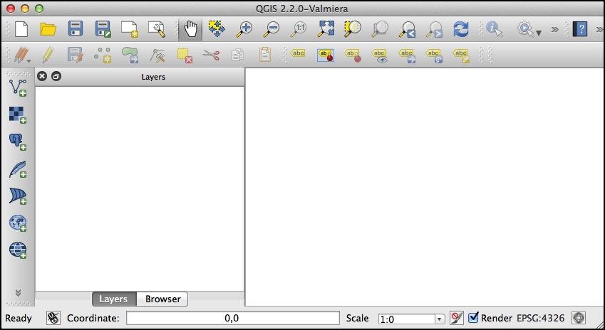
If everything goes well, the QGIS application will start up and you will be greeted with the following window:

Installing and running QGIS

Note

The exact appearance of the window might vary depending on your operating system. Don't worry, as long as a window appears, which looks something like the one shown in the previous screenshot, you are running QGIS.

You don't need to worry too much about the QGIS user interface right now; the QGIS User Guide describes the interface and various options in great detail. Rather than duplicating this information, let's take a look under the hood to see how QGIS works.

Understanding QGIS concepts

To understand QGIS, you will have to become familiar with the following basic terms and concepts:

  • QGIS works with geospatial information loaded from a variety of data sources. These data sources can include vector and raster data files on a disk, a variety of spatial databases, and even web services such as Web Map Service (WMS) servers that provide geospatial data from the Internet.
  • Wherever the data comes from, it is retrieved by QGIS and displayed as a map layer. Map layers can be shown or hidden, and also customized in various ways to affect the way the data is displayed on the map.
  • The map layers are then combined and displayed on a map.
  • Finally, the various map layers, the map, and the other settings, all make up a project. QGIS always has one and only one project that it is working with. The project consists of all the map layers, the map display options, and the various settings that are currently loaded into QGIS.

These concepts are related in the following manner:

Understanding QGIS concepts

Note

Note that the data sources are outside QGIS. While the map layer refers to a data source, the data itself is stored somewhere else, for example, in a file on a disk or within a database.

Whenever you are working with QGIS, you are always working within the current project. You can save projects and reload them later, or start a new project to reset QGIS back to its original state.

CONTINUE READING
83
Tech Concepts
36
Programming languages
73
Tech Tools
Icon Unlimited access to the largest independent learning library in tech of over 8,000 expert-authored tech books and videos.
Icon Innovative learning tools, including AI book assistants, code context explainers, and text-to-speech.
Icon 50+ new titles added per month and exclusive early access to books as they are being written.
Building Mapping Applications with QGIS
notes
bookmark Notes and Bookmarks search Search in title playlist Add to playlist font-size Font size

Change the font size

margin-width Margin width

Change margin width

day-mode Day/Sepia/Night Modes

Change background colour

Close icon Search
Country selected

Close icon Your notes and bookmarks

Confirmation

Modal Close icon
claim successful

Buy this book with your credits?

Modal Close icon
Are you sure you want to buy this book with one of your credits?
Close
YES, BUY

Submit Your Feedback

Modal Close icon
Modal Close icon
Modal Close icon