
Now let us get down to the real use of Google Map Maker. In this section, we will explore the core tools and functionalities of Google Map Maker that will help us to move from being a newbie to a professional mapper and reviewer in Google Map Maker. Remember all your edits and reviews, however minor, are always credited to your profile.
I am sure, by now, you must have gained some insight into how Google Map Maker works—Google Map Maker has a community of voluntary mappers who have a desire to map the places they know and love. However, since recently Google has been integrating its location services in search and across their product line, businesses have seen the need for them to increase their online visibility through listings in Google Geo tools such as Google Places, Google Maps, Google Maps Mobile, and so on. In a bid to make the best use of these services, businesses are also putting up their business in Google Maps through Google Map Maker. This is perhaps the easiest and quickest way to add a business listing to Google Geo products as we will see in a short while.
Similarly, Google Maps created by local mappers are increasingly finding use in humanitarian crises. A case in point is the response to the Mapping appeal by Pakistani Map Maker volunteers Omer Sheikh and Jabran Rafique to a series of landslides that occurred after floods that hit Atta Abad, a semi-autonomous region of Pakistan, causing loss of lives and blocking the Hunza River in January 2010. Omer Sheikh and Jabran Rafique come out strongly mapping the area and putting an appeal to the entire world to help improve the rescue effort through accurate mapping of the region. As Omer put it in the Google Lat Long Blog (http://google-latlong.blogspot.com/2010/06/map-makers-respond-to-pakistan.html):
From the onset of the disaster, the international community seemed to be hardly aware of the situation. Worst...I was unable to locate on a map where Atta Abad was! As a mapper, my first appeal went out to the Google Map Maker team, and Google Maps Pakistan.
They went ahead and built a website (http://www.local.com.pk/hunza/) making use of the Google Maps API to visualize the data and together with the Google Map Maker Team and the UN, made the data available for download publically, which helped with the humanitarian crisis. A similar appeal was made for the Horn of Africa Conflict in 2011, see http://goo.gl/G71Yv.
Please note that the best way you can get a business or an incorrectly-placed feature in Google Maps (or correct the same) is by editing or reviewing it in Google Map Maker. In adding and editing features in Google Map Maker, it's worth mentioning that geographic features in a map can be represented in two different data formats:
Raster data: The representation of geographic information as regular grid cell(s).Think of this as the background satellite image upon which we will be creating maps and features.
Vector data: The representation of geographic objects with the basic elements of points, lines, and polygons. Think of this as the point, linear, and polygonal features; we will very shortly learn how to create these features in Google Map Maker. Point and polygons can be used to represent the same features, but at a different scale and depending on the level of detail desired.
We will be adding vector data (hotels, roads, paths, cafes, shopping malls) to the already provided raster data (satellite image) by Google. The core features and operations we are going to learn how to quickly perform are:
As just discussed previously, the features to be added to Google Maps are either going to be in a point, linear, or a polygon form. Let's go through the process of adding each of these features to Google map maker:
POI could be a business, a cafe, a hotel, or even an apartment. Follow these steps to add POI to Google Map Maker:
To add a POI on Google Map Maker, fire http://www.google.com/mapmaker.
By default, it should load the current location you are accessing the Internet from. If that's where you would like to Map, proceed. If not, search the place you want to map in the search bar as earlier discussed.
Zoom in on the map to level 19 (the Zoom bar has 20 units), so that you can map the POI to a high detail. Add the satellite layer by clicking on Satellite in the upper-left corner within the Map view area, so that you can trace the feature you want at pinpoint accuracy, as shown in the following screenshot:

Then click on the Add a Place drop-down, select the category—your POI falls under—from the given Category:

If the POI does not fall under any of the given categories, click on Type to select from over 2000+ categories and enter the feature's category and name:

Continue to toggle up the info panel on the left, this allows you to enter more descriptive information about the POI such as the telephone, website, working hours, and so on and then click on Save:

Congratulations, you have added a new POI onto Google Maps. The feature will be reviewed by other Google Map makers and upon confirmation, will be reviewed and published in Google Maps. You can continue to add more POI as you await review of your edits. Remember about the private policy regarding personal and private information. Do not add features such as houses, private mobile numbers, private e-mail addresses, and so on. Such edits may be denied or delayed in the reviewing process.
Businesses and other POIs can be added as polygons based on the level of generalization needed. For instance, tracing our building, property, and forest boundaries is a simple way of adding POIs by polygon.
To add a polygonal feature in Google Map Maker, follow these steps:
From the home screen of the Map Maker UI, click on Add New.
Select Add Building Outlines, as shown in the following screenshot:

Select the category in which the feature falls under and proceed to trace out the feature within the map view; trace till you get back to the initial point.

Notice the pop-up box that pops up on the bottom-left corner of the screen when you start drawing the polygon. It provides simple tips and instructions on how best to draw your feature. Also note the Draw menu at the upper-right corner that toggles up. It provides additional tools for editing and changing the polygon feature.
To close the polygon, double-click on the last/starting point upon which a detail pane is toggled up for you to add descriptive information on the feature, as shown here:

While still adding the descriptive details, notice the new menu toggled at the top of the map view area. This menu allows you to edit the polygon that you have traced. You can move the feature to some other location; you can cut a hole through it in order to create an Island feature within this feature. An example of a cut made within a larger polygon feature is shown here:

Add the details, description, and address that define the polygonal feature as well. click Save. Continue to add more features as you await approval/moderation of your feature.
Linear features such as roads, railway lines, or trails/path are perhaps the easiest to add to Google Map Maker. Primarily, because you do not need to provide all the details for your edit to go through. Simply tracing and creating a road or a trail is good enough even if you do not have other key details such as name, type of road, and so on. To add a line feature, follow these steps:
On the home screen of Map Maker, click on Add New.
Select Add Roads, Rivers, Railways from the drop-down, as shown here:

Proceed to add the category within which your feature falls and off you go to create it.
Click on the starting point of your feature and carefully proceed to trace/digitize the feature outline, paying closer attention to the curves and turning points:

Should you make a wrong point, don't worry, you can always undo with Ctrl + Z on Windows, Cmd + Z on Mac, or you can as well right-click on the point and select Delete this point and proceed making your correct trace points, as shown in the following screenshot:

Double-click on the end point to finish your feature and add the relevant details, if available and appropriate, such as road name, road attributes such as number of lanes, dividers, surface type, or access then hit Save, as shown here:

Although adding the descriptive information about line features is not compulsory, it is important to note that these are the features that make the directions work accordingly. Details such as road priority, number of lanes, average speed, surface types, and road conditions are some of the variables that the directions and navigation (wherever supported) take into consideration before optimizing the best route.
Some type of line features, for example, river, water bodies require mixing two types of drawing features—line feature and polygon feature. This would involve drawing the line part as a line feature and then when it's a lake, for instance, you draw the polygon as two separate features but with the same name.
Directions are not much of a feature in Google Maps. Based on the existing features created in Google Map Maker, you can create/determine the directions between any of them. To create a direction in Google Map Maker, it's important to know that you need at least two existing features in Google Map Maker.
To get started, find/identify the two points that you need to create directions between.
Right-click on one of the features and select how you want the directions—either to the feature or from the feature—as shown in the following screenshot:

Type in the name of the destination/current location, depending on how you want your directions and select what kind of directions you want: By Car (Driving),Walking, or Bicycle (Cycling) by selecting from the respective icons and then create the directions. A route map is created with clear turn-by-turn instructions between the selected destinations, as shown here:

Editing features in Google Map Maker involves two things:
Editing feature location for a wrongfully-placed feature
Editing feature-descriptive data for inaccuracy
Either way, the procedure for doing so is similar and the same as the procedure for adding new features. It involves identifying/spotting the inaccuracies or incorrectness in a feature and then proceeding to Google Map Maker, to search, identify the feature, and correct the inaccuracy. Let us take a look at how to edit each class of feature as discussed previously:
Assuming you have spotted an erroneously-mapped feature while you were either adding new features or while using one of other Google Geo Platforms, the way to go about to correct it is simple; here it is:
Visit the Google Map Maker application by visiting http://www.google.com/mapmaker.
Find the feature through the search area as previously shown. The feature(s) related to your query will be populated in the map view area; identity the one you want to edit.
Click on it within the map view area and select Edit, as shown here:

Select what/how you want to edit the feature:

Edit this place: This option will allow you to edit the feature details and descriptive information as shown here:

Move location: If the feature is incorrectly placed in its location, you can drag and move it to its correct location by using this option:

Report this: Use this option if you would just like to report a feature as wrongfully placed or with incorrect details to draw the attention of the community to correct it appropriately. Provide the reason as to why you are reporting this feature by selecting one of the reasons: Spam Edit, Violating Privacy, Trademarks, Duplicity, and so on. You can only provide a single reason and you must provide a short description remark for the reason of reporting, as shown in the following screenshot:

Delete this :Delete a feature if you are sure it is either incorrectly placed, is a duplicate feature, or for any of the reasons listed here:

Editing linear features such as roads or rivers involves either fixing the missing links, correcting wrong turns within the feature, or altogether deleting a wrongfully-drawn feature. Note that to edit a feature, you must search for it by name and then when it is populated in the map view area, you can edit it. Once highlighted, on the left pane, select Edit and select what or the way by which you want to edit the feature:
Edit this route: This option takes you to the route after which you can correct what is incorrect.

Either the details or the route itself could be incorrect. We can correct this by hard-pressing the mouse/touchpad along the incorrect points and dragging each point to the correct place as shown in the following screenshot:

Report this and Delete this work as earlier discussed. You can report a route as incorrect and provide the reasons as well as delete it for the same reason.
Basically, polygonal features are similar to point features but at a different generalization or scale. So editing them is very similar to the points, assuming you have identified the error either in the boundaries of the feature or the details.
Reviewing edits in Google Map Maker simply involves checking on the edits made by other mappers and agreeing/disagreeing with the feature's location and/or the descriptive information provided. This is the simple concept that insures reflection of the features on the ground and as seen by the locals within the neighborhood. Anyone can dispute on the appearance or accuracy of features if it aggrieves them and/or infringes on their personal privacy.
Reviewing edits is very easy and just like edits, reviews also are credited to your profile contributions in Google Map Maker. There are three ways by which you can get started in making reviews. The upper-left pane of the Google Map Maker displays the various activities happening in Google Map Maker, including edit count, reviews, and so on. The activity view stream is as shown here:
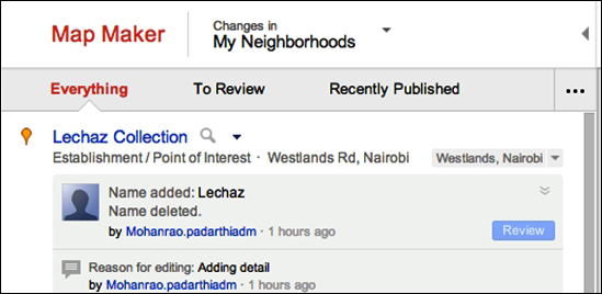
We can start our reviewing through these activity streams, as explained here:
Everything: This stream shows all the activities within the current map view of the Map Maker Scrolling through his section allows you to see all the activities including the new features created, edit's pending review, and the reasons. You can review directly from here, but it's best to move to the next tab, which is explained in the next point.
To Review: This is the section that allows you to view all those edits made within the current map view that need review. Here is how you do this:
Simply scroll and identify the features you would like to review.
Click Review. This opens up the feature within the map view:

Go through the feature location and the details carefully and when convinced that it's correct, go ahead, agree, and review, that is, agree that changes are correct:

If not, provide the reason for rejecting the edit and/or request for more information from the user through the remarks section and submit as shown here:

Browse by Filters: This is the hidden function that is accessed if you expand the left pane by clicking on the three dots, as shown here:

This section allows you to view the types of edits through a simple filter. Say, you just want to review point features and arrange them from oldest to newest or want to do line features only, then this is the tool for you. Try it out.
You can browse or explore places in Google Map Maker fairly easily. This is just like you would do in other Google Geo platforms such as Google Maps and Google Earth. After all, most of the features/places found in all the other Google Geo platforms for most of the world are contributed by volunteers through Google Map Maker. Browsing features/places in all simplicity involves searching for the features in the Search pane and tour query will be displayed in the map view area. However, Browse feature is much more than just a simple search tool. The advanced feature of Browse enables users to find detailed and custom maps. Some of such examples are showcased at http://geography.pk/_en/2011/05/08/an-overview-of-mapped-pakistan-at-google-map-maker/. Sometimes, the same feature may exist multiple times or under different/alternative names.
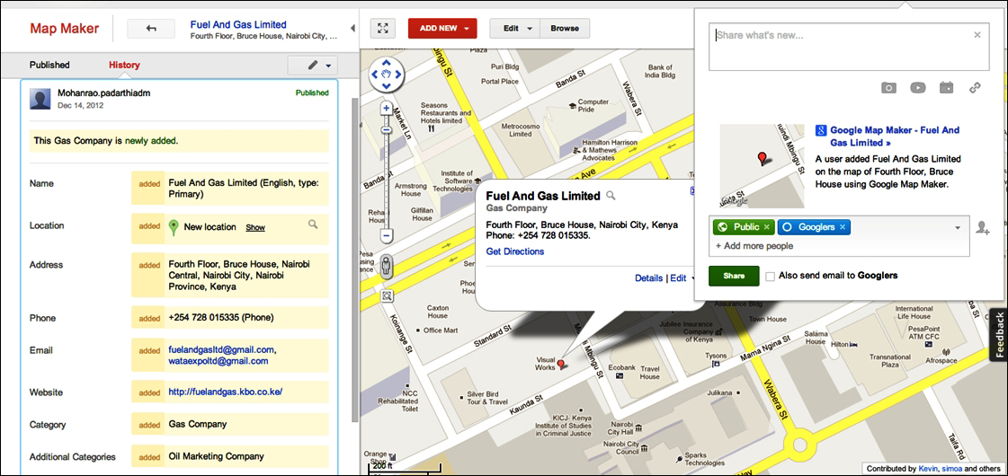
Would you like to share your edits or any features from Google Map Maker with your friends? Don't worry, it's very easy. You can share your edits as you edit or review them or even share other people's edits. Simply search for the feature that has been published, or the one you have just edited, or is in the map view area and click on the Share icon at the upper-right corner of the map view. The highlighted feature will be posted to your Google Plus account, if you have one, to all your friends and the public if you want to: