Book Image

GeoServer Beginner's Guide

Book Image

GeoServer Beginner's Guide

Overview of this book

GeoServer is an open source server-side software written in Java that allows users to share and edit geospatial data. Designed for interoperability, it publishes data from any major spatial data source using open standards. GeoServer allows you to display your spatial information to the world. Implementing the Web Map Service (WMS) standard, GeoServer can create maps in a variety of output formats. OpenLayers, a free mapping library, is integrated into GeoServer, making map generation quick and easy. GeoServer is built on Geotools, an open source Java GIS toolkit.GeoServer Beginner's Guide gives you a kick start to build custom maps using your data without the need for costly commercial software licenses and restrictions. Even if you do not have prior GIS knowledge, you will be able to make interactive maps after reading this book.You will install GeoServer, access your data from a database, style points, lines, polygons, and labels to impress site visitors with real-time maps.Follow along through a step-by-step guide that installs GeoServer in minutes. Explore the web-based administrative interface to connect to backend data stores such as MySQL, PostGIS, MSSQL, and Oracle. Display your data on web-based interactive maps, style lines, points, polygons, and embed images to visualize this data for your web visitors. Walk away from this book with a working application ready for production.After reading the GeoServer Beginner's Guide, you will have beautiful, custom maps on your website built using your geospatial data.
Table of Contents (20 chapters)
GeoServer Beginner's Guide
Credits
About the Authors
About the Reviewers
www.PacktPub.com
Preface
Index

About & Status


This area gives you information about runtime variables and how GeoServer is described to clients that connect to it.

Server Status

Server Status gives you a nice overview of the main configuration parameters and information about the current state of the GeoServer. The information is organized in a table view. Other than being informative, this view lets you perform some maintenance operations. We will describe the main items listed in the following screenshot:

Locks

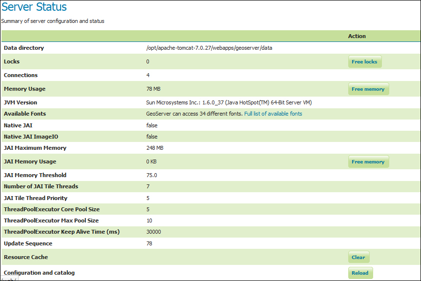
Using Transactional Web Feature Service (WFS-T) a client may edit the configured feature types. To avoid data corruption, GeoServer locks the data on which a transaction is required until it ends. If the number shown is greater than one, then there are some transactions going on with your data. The Free Locks button lets you reset a hung editing session, removing any orphan processes to free locks that might have been abandoned.

Connections

This shows you the number of vector data store connections. Vector data...