Book Image

QGIS Quick Start Guide

By : Andrew Cutts
Book Image

QGIS Quick Start Guide

By: Andrew Cutts

Overview of this book

QGIS is a user friendly, open source geographic information system (GIS). The popularity of open source GIS and QGIS, in particular, has been growing rapidly over the last few years. This book is designed to help beginners learn about all the tools required to use QGIS 3.4. This book will provide you with clear, step-by-step instructions to help you apply your GIS knowledge to QGIS. You begin with an overview of QGIS 3.4 and its installation. You will learn how to load existing spatial data and create vector data from scratch. You will then be creating styles and labels for maps. The final two chapters demonstrate the Processing toolbox and include a brief investigation on how to extend QGIS. Throughout this book, we will be using the GeoPackage format, and we will also discuss how QGIS can support many different types of data. Finally, you will learn where to get help and how to become engaged with the GIS community.
Table of Contents (9 chapters)

Layer Styling Panel

The Layer Styling Panel offers a shortcut to the styling options of the Layer Properties dialog box. It allows the user to make updates to the styling of a layer and see it update instantly on the map.

Open QGIS. Load the following layers from the GeoPackage, and keep them in the following order in the Layers panel:

  • Airports
  • majrivers
  • grassland
  • alaska

The layers are ordered from the top in points, lines, and polygons for ease of visibility. Turn on the Layer Styling Panel. Do this by clicking on View | Panels | Layer Styling Panel, as shown in the following screenshot:

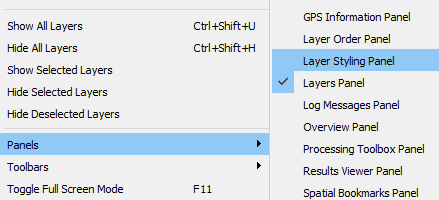
Activating the Layer Styling Panel
Once you turn on the Layer Styling Panel make sure that the checkbox next to Live update (bottom right of the Panel) is ticked so any updates can be seen as they are made.

Right-click on the alaska layer and select the Zoom to Layer option. Your screen...