Book Image

QGIS Quick Start Guide

By : Andrew Cutts
Book Image

QGIS Quick Start Guide

By: Andrew Cutts

Overview of this book

QGIS is a user friendly, open source geographic information system (GIS). The popularity of open source GIS and QGIS, in particular, has been growing rapidly over the last few years. This book is designed to help beginners learn about all the tools required to use QGIS 3.4. This book will provide you with clear, step-by-step instructions to help you apply your GIS knowledge to QGIS. You begin with an overview of QGIS 3.4 and its installation. You will learn how to load existing spatial data and create vector data from scratch. You will then be creating styles and labels for maps. The final two chapters demonstrate the Processing toolbox and include a brief investigation on how to extend QGIS. Throughout this book, we will be using the GeoPackage format, and we will also discuss how QGIS can support many different types of data. Finally, you will learn where to get help and how to become engaged with the GIS community.
Table of Contents (9 chapters)

Raster analysis

Create a new QGIS project and load into the map the landcover.img file. We'll use this layer to demonstrate a couple of the many raster processing tools in QGIS. On load, we have landcover classes with values ranging from 0 to 13. The value zero appears to correspond to water. In this example, we're going to set all of the values that are equal to zero to nodata. In GIS we would set raster data to no data when we have data that we don't want to use or display.

To change the 0 values in the Landcover dataset to nodata, select Raster | Conversion | Translate (Convert Format) as shown in the following screenshot:

Calling the Translate tool

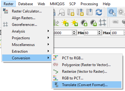
The Translate tool is very helpful to convert rasters into different data types and formats. It's built on the GDAL translate tool; you can read about the options with gdal_translate here: https://www.gdal...