Book Image

ROS Programming: Building Powerful Robots

By : Anil Mahtani, Aaron Martinez, Enrique Fernandez Perdomo, Luis Sánchez, Lentin Joseph
Book Image

ROS Programming: Building Powerful Robots

By: Anil Mahtani, Aaron Martinez, Enrique Fernandez Perdomo, Luis Sánchez, Lentin Joseph

Overview of this book

This learning path is designed to help you program and build your robots using open source ROS libraries and tools. We start with the installation and basic concepts, then continue with the more complex modules available in ROS, such as sensor and actuator integration (drivers), navigation and mapping (so you can create an autonomous mobile robot), manipulation, computer vision, perception in 3D with PCL, and more. We then discuss advanced concepts in robotics and how to program using ROS. You'll get a deep overview of the ROS framework, which will give you a clear idea of how ROS really works. During the course of the book, you will learn how to build models of complex robots, and simulate and interface the robot using the ROS MoveIt motion planning library and ROS navigation stacks. We'll go through great projects such as building a self-driving car, an autonomous mobile robot, and image recognition using deep learning and ROS. You can find beginner, intermediate, and expert ROS robotics applications inside! It includes content from the following Packt products: ? Effective Robotics Programming with ROS - Third Edition ? Mastering ROS for Robotics Programming ? ROS Robotics Projects
Table of Contents (37 chapters)
Title page
Copyright and Credits
Packt Upsell
Preface
Bibliography
Index

Functional block diagram of a typical self-driving car


The following shows the important components of a self-driving vehicle. The list of parts and their functionalities will be discussed in this section. We'll also look at the exact sensor that was used in the autonomous car for the DARPA Challenge.

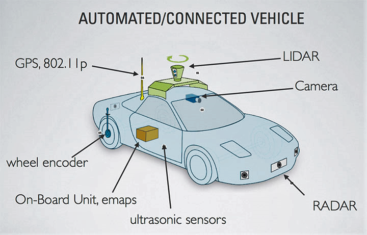
Figure 4: Important components of a self-driving car

GPS, IMU, and wheel encoders

As you know, the Global Positioning System (GPS) helps us determine the global position of a vehicle with the help of GPS satellites. The latitude and longitude of the vehicle can be calculated from the GPS data. The accuracy of GPS can vary with the type of sensor; some sensors have an error in the range of meters, and some have less than 1 meter of error. We can find vehicle state by combining GPS, inertial measurement unit (IMU) and wheel odometry data, and by using sensor fusion algorithms. This can give better estimate of the vehicle. Let's look at the position estimation modules used for the DARPA Challenge...