Book Image

Learning ArcGIS Runtime SDK for .NET

By : Ron Vincent
Book Image

Learning ArcGIS Runtime SDK for .NET

By: Ron Vincent

Overview of this book

ArcGIS is a geographic information system (GIS) that enables you to work with maps and geographic information. It can be used to create and utilize maps, compile geographic data, analyze mapped information, share and discover geographic information and manage geographic information in a database. This book starts by showing you where ArcGIS Runtime fits within Esri’s overall platform strategy. You'll create an initial map using the SDK, then use it to get an understanding of the MVVM model. You'll find out about the different kinds of layers and start adding layers, and you'll learn to transform maps into a 3D scene. The next chapters will help you comprehend and extract information contained in the maps using co-ordinates and layer objects. Towards the end, you will learn to set the symbology, decide whether to use 2D or 3D, see how to implement 2D or 3D, and learn to search and find objects. You'll also get to grips with many other standard features of the Application Programming Interface (API), including create applications and finally testing, licensing, and deploying them. Once completed, you will be able to meet most of the common requirements of any mapping application for desktop or mobile platforms.
Table of Contents (19 chapters)
Learning ArcGIS Runtime SDK for .NET
Credits
About the Author
About the Reviewers
www.PacktPub.com
Preface
3
Maps and Layers
12
Configuring, Licensing, and Deploying
Index

IdentifyTask


Imagine for a moment that you have multiple layers in your map or scene, and you want to click on a particular location and find everything at that location. See the following image:

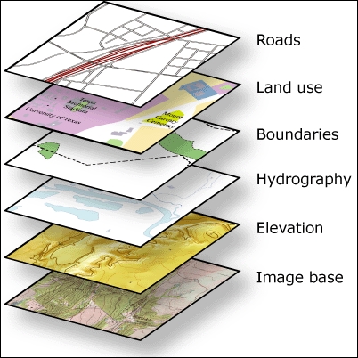
If you click on these layers, the IdentifyTask object will return every feature in every layer that is located where you clicked. The IdentifyTask class uses the concept of a hit test. A hit test simply means that if the point where the user clicks intersects with any feature in any layer, those features are returned to IdentifyTask. It's possible to perform an Identify operation on both online and offline data. Let's look at an online example first, and then explore this further with the same kind of operation but with offline data.

All examples in this section are in the code provided with this book, which is called Chapter7a.

The online Identify task

Let's add some code, and then discuss how IdentifyTask works using an online service:

  1. In your project, open the MapViewBehavior.cs file and add the following...