

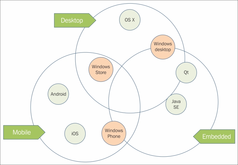
What are the language options? With ArcGIS Runtime, you can choose either .NET, Java SE, Android, Objective-C, C++ using Qt, or a combination of C++ and JavaScript by using Qt and QML. The beauty of this feature is that it's completely up to you and your team of developers. If you work alone, you probably already have a language in mind, and based on the title of this book, you're probably a .NET developer. If you're not a .NET developer, the good news is that the things you learn here will apply to the other flavors of ArcGIS Runtime. There will be some minor differences in how Runtime is implemented in your language of choice, however. With that said, which language choices do you have based on the OS? Refer to the following diagram. On the desktop, you can use Objective-C, .NET, C++ via Qt and QML, and Java SE. On mobile devices, you can use Objective-C, Java with the Android SDK, or .NET for Windows Phone. For embedded apps, you can use Java SE, C++ via Qt and QML, or .NET:
One of the awesome benefits of many of these languages is that you can build apps that are truly cross-platform. From the software development perspective, this means you can write your code once and run it on many platforms. For example, it's possible to use the .NET SDK to write an app that shares code and can be run on Windows, Windows Store, and Windows Phone. With the Qt version of ArcGIS Runtime, you can go even further and write your code so that it runs on nearly all platforms. That's amazing! But don't feel left out. Later this year, Esri will be releasing the Xamarin® version of ArcGIS Runtime, which will allow you to run your .NET apps on iOS and Android too. As a result, you get more bang for your buck.